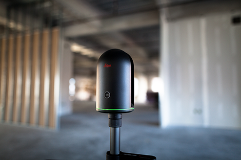
Weighing less than a bag of sugar, the Leica BLK360 connects to an iPad and the Autodesk ReCap 360 Pro app
Leica Geosystems has launched its BLK360 Imaging laser 3D scanner alongside Autodesk’s ReCap 360 Pro app.
The BLK360 is one of the smallest and lightest of 3D scanners of its kind, but also, as a result of its single-button controls and mobile device app, offers a simple user experience.
The 3D scanner features a 60m measurement range for full dome scans, with a complete full-dome laser scan, 3D panoramic image capture and transfer to the iPad Pro taking a claimed three minutes.
Self-leveling, the miniaturised 3D imaging laser scanner weighs about 1kg and easily fits into a bag or large pocket.
Capable of capturing full-color panoramic images overlaid on a high accuracy point cloud, accurate at distances up to 60 meters, the device captures HDR images, as well as thermal images, has built in lights, so it can work in low light.
The device was described as waterproof and could be mounted on a tripod, on a ceiling or on its stand.
Using the ReCap Pro 360 mobile app, the BLK360 streams image and point cloud data to iPad, with the app filtering and registering scan data in real-time.
After capture, ReCap 360 Pro enables for point cloud data transfer to a number of CAD, BIM, VR and AR applications.
“When Autodesk first introduced ReCap, it was for one purpose: the democratisation of reality capture,” said Aaron Morris, who oversees reality solutions at Autodesk.
“We saw the tremendous power of this technology for the AEC industry, but realized that the cost and portability of scanners combined with difficult-to-use data was limiting the adoption of reality capture. Autodesk’s collaboration with Leica Geosystems helps solve these issues by giving just about anyone access to the amazing advantages of reality data.”
A BLK360 and Autodesk ReCap 360 Pro Bundle will be available to order in March 2017 at a suggested retail price is $15,990/€15,000.


